
Based on the needs and requirements of many public authorities which are known as actors for use and update of geospatial information topics, ASIG proposed a new aerial photography which will serve as a map-based unified for the whole Albanian territory. Albanian Government with the decision K.ZH.T. No.14 dated 23.09.2014, published in the Official Journal No. 147/2014 titled “Creating the System of Geospatial data” first stage, took the decision to implement this project by funding this project.
Aerial photography will obviously be useful for the recognition of the current state of the Albanian geographical features and formulation national plans linked to the mainland. In addition, it is possible to conduct research and analyze relevant situations, comparing existing orthophoto in 2007 and newly developed in 2015.
such as coastal erosion, forest fund, the development of mineral resources, land use changes, eg from farmland in the housing areas, from forest to agricultural land; new buildings and loss of buildings, natural disasters, eg landslides and forest fires, the implementation of population registration system, national address system, etc, producing in this way a digital model of the terrain, through scanning of the territory (DTS) and Orthophoto RGB / CIR which will be produced for the first time in Albania in this form. RGB/ CIR të cilat do të prodhohen për herë të parë në Shqipëri në këtë trajtë
This will be the first stage of creating geospatial data system to support the development and management of the region.
The project area is 28,748 sq km, which represents the total area of ??the Republic of Albania.
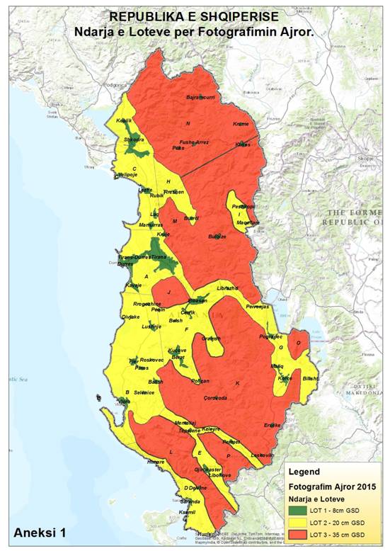
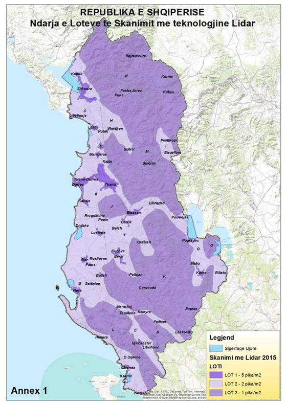
The project area will be divided into three main lots with different precision for aerial photography, LIDAR scanning, DTM and DTS creation from LIDAR scanning and orthophoto production.
| Nr | LOT | ZONE | SIPERFAQE (km2) | Fotogradi Ajrore dhe AT (GSD në metra) | Ortofoto |
| 1 | LOT 1 | Zonë Urbane | 1 028 | 0.08 | Nga fotografitë ajrore me GSD 0.08 |
| 2 | LOT 2 | Zonë Rurale | 10 340 | 0.20 | Nga fotografitë ajrore me GSD 0.20 |
| 3 | LOT 3 | Zonë Malore | 17 380 | 0.35 | Nga fotografitë ajrore me GSD 0.35 |
| Nr | LOT | ZONE | Sipërfaqe (km2) | Skanimi LiDAR dhe prodhimi DTM |
| 1 | LOT 1 | Zonë Urbane | 1 028 | 5 pikë/m2 |
| 2 | LOT 2 | Zonë Rurale | 9 960 | 2 pikë/m2 |
| 3 | LOT 3 | Zonë Malore | 17 349 | 1 pikë/m2 |
Ndarja e Lote-ve për Fotografimin Ajror
Ndarja e Lot-ve të Skanimit me teknologjine LIDAR
TERMA REFERENCE (TOR)
“ PROJEKTET TEKNIKE PËR RRJETET E KOMBINUARA GJEODEZIKE TË KRGJSH-2010”