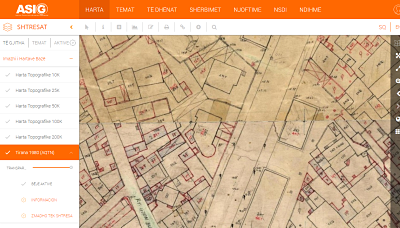
ASIG has published maps available on the National Geoportal provided by the Central Technical Archive of Construction (AQTN) titled “1:500 Scale Sheets for the city of Tirana, 1980.” These sheets were constructed using tacheometric methods by the former Geology-Geodesy enterprise. The primary purpose of creating these sheets was to generate maps and plans for territories where cities and large engineering works were located, at scales of 1:500 and 1:1000. ASIG’s goal in publishing them is to assist institutions and the public, particularly in matters related to planning and property. For more information, you can refer to the metadata of the layer “Tirana 1980 (AQTN)” at the following link: https://geoportal.asig.gov.al/geonetwork/srv/alb/catalog.search?auto=true#/metadata/abfb3644-2f0d-4024-864c-0629b04a0e34